With five map sheets at a scale of 1:50,000, our maps cover the entire stretch of the Kungsleden trail from Abisko in the north to Hemavan in the south. Our maps offer a unique level of detail. Unlike other maps of the Kungsleden on the market, we haven’t simply enlarged a base map designed for 1:100,000. For those dreaming of—or actively planning—to hike or ski the entire trail, we also offer a practical atlas of the full route that fits in your pocket, featuring the same detailed map information at a 1:50,000 scale.
Maps from the Nordic region’s leading outdoor publisher – specialists in outdoor maps.
Calazo Publishing is the obvious choice when you’re looking for high-quality maps of Sweden and the Nordic countries. We are experts in topographic maps, hiking maps, road maps, and mountain maps.
Our maps are printed on Tyvek, a durable and completely waterproof material that withstands wind, moisture, and field use. We continuously update trails and routes on all our maps. Whether you are planning a day trip, a weekend hike, or a multi-week adventure in the Swedish mountains – from coast to inland – you’ll find the right map at Calazo.
Our outdoor maps and mountain maps offer such a level of detail that you can navigate with confidence, and materials that withstand weather and wind.

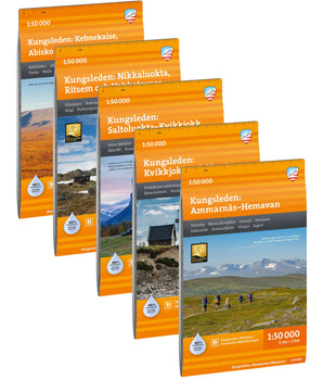 Kungsleden map package


 Friluftsatlas Kungsleden 1:50 000 €29,90 /
 Fjällvandra längs Kungsleden €29,90 /
 Best hiking in Sweden: Kungsleden €29,90 /
 På fjälltur Kungsleden €19,90 /


